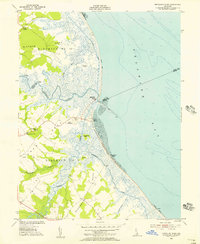
1955 Map of Mispillion River
USGS Topo · Published 1956About this map
The Mispillion River serves as the dividing line between Kent and Sussex counties as it flows into the Delaware Bay. This coastal landscape is defined by vast salt marshes and complex drainage systems, including the Draper-Bennet Ditch and several flood gates near the shore. The strategic importance of the river mouth is highlighted by the presence of Fort Saulsbury and the Mispillion Light Tower, providing a look at mid-century coastal defense and maritime navigation. Small shoreline settlements like Slaughter Beach, Cedar Beach, and Fowler Beach dot the sandy barrier, while inland, the community of Scotts Corners and river landings like Majorleys Landing and Cains Landing suggest a landscape tied to both waterborne transit and agricultural necks. Local family and community roots can be traced through the Cedar Neck Ch and Cedar Neck Sch, along with several smaller marked cemeteries located in Milford Neck.
Find a feature on this map
32 named features on this map. Tap any name to fly to it.
Don’t see what you’re looking for? This feature index may not catch every label — zoom into the map to look around manually.
Map Details
Editions of this 1955 Mispillion River Map
3 editions found
Other maps of this area

1890 · Maurice Cove
USGS Topo · 1:62,500

1891 · Maurice Cove
USGS Topo · 1:62,500

1899 · Vineland
USGS Topo · 1:125,000

1918 · Cedar Creek
USGS Topo · 1:62,500

1918 · Cape Henlopen
USGS Topo · 1:62,500

1919 · Cedar Creek
USGS Topo · 1:62,500

1919 · Vineland
USGS Topo · 1:125,000

1934 · Bowers
USGS Topo · 1:48,000
1936 · Bowers
USGS Topo · 1:62,500

1937 · Cape Henlopen
USGS Topo · 1:62,500