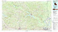
1985 Map of Monroe North
USGS Topo · Published 1988About this map
Grambling State University and Louisiana Tech University anchor the southern corridor of this North Louisiana region, which is defined by the intersection of academic institutions and the extractive industries of the mid-1980s. The landscape transitions from the dense timberlands of the Kisatchie National Forest in the west to the expansive Monroe Gas Field and Calhoun Gas and Oil Field in the east. Hydrological features dominate the central terrain, notably Bayou D'Arbonne Lake and the complex wetlands of the D'Arbonne National Wildlife Refuge. Transportation networks follow the historic rail lines of the Illinois Central Gulf RR, while the Ouachita River and Bayou Bartholomew provide the traditional watery arteries for the twin cities of Monroe and West Monroe. Smaller settlements like Dubach, Bernice, and Marion remain connected by a web of state highways that cut through the rolling hills of Union, Lincoln, and Claiborne parishes.
Find a feature on this map
106 named features on this map. Tap any name to fly to it.
Don’t see what you’re looking for? This feature index may not catch every label — zoom into the map to look around manually.
Map Details
Editions of this 1985 Monroe North Map
2 editions found

Other maps of this area

1927 · El Dorado
USGS Topo · 1:62,500

1930 · El Dorado
USGS Topo · 1:62,500

1933 · Strong
USGS Topo · 1:62,500

1934 · Felsenthal
USGS Topo · 1:62,500

1935 · Collinston
USGS Topo · 1:62,500

1935 · Naff
USGS Topo · 1:62,500

1935 · Alto
USGS Topo · 1:62,500

1935 · Drew
USGS Topo · 1:62,500

1935 · Haile
USGS Topo · 1:62,500

1937 · Strong
USGS Topo · 1:62,500