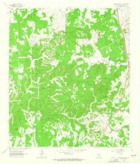
1963 Map of Monument Hill
USGS Topo · Published 1965About this map
The Blanco County landscape depicted here is dominated by the complex drainage systems of the Pedernales River basin during the early 1960s. Miller Creek and McCall Creek wind through a series of prominent limestone rises, including Monument Hill and Martin Mountain, while a network of springs like Walnut Spring and Duncan Spring feed the local watercourses. The map captures the area before modern development, showing a rural infrastructure of unimproved roads such as Miller Road and the presence of a remote Landing Strip. These features, along with numerous gravel pits and well sites, illustrate a mid-century economy focused on ranching and resource extraction. The topography is further detailed by the inclusion of local landmarks like Brushy Top and Rattlesnake Hill, providing a clear record of the territory's traditional nomenclature and property divisions.
Find a feature on this map
24 named features on this map. Tap any name to fly to it.
Don’t see what you’re looking for? This feature index may not catch every label — zoom into the map to look around manually.
Map Details
Editions of this 1963 Monument Hill Map
2 editions found
Other maps of this area

1887 · Blanco
USGS Topo · 1:125,000

1894 · Fredericksburg
USGS Topo · 1:125,000

1894 · Blanco
USGS Topo · 1:125,000

1954 · Llano
USGS Topo · 1:250,000

1955 · Llano
USGS Topo · 1:250,000

1956 · Llano
USGS Topo · 1:250,000

1961 · Hye
USGS Topo · 1:24,000

1961 · Rocky Creek
USGS Topo · 1:24,000
1961 · Johnson City
USGS Topo · 1:24,000

1963 · Yeager Creek
USGS Topo · 1:24,000