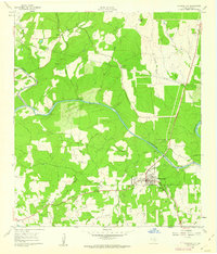
1961 Map of Johnson City
USGS Topo · Published 1962About this map
Johnson City serves as the focal point of this early 1960s Hill Country survey, centered near the confluence of Towhead Creek and Flat Creek before they join the Pedernales River. The town is well-established with civic infrastructure including a High Sch, Hospital, and Fairgrounds. Beyond the town center, the landscape is marked by small private landing strips such as Waller Airfield and Winter Airfield, reflecting the importance of light aviation in rural Texas at this time.
Find a feature on this map
30 named features on this map. Tap any name to fly to it.
Don’t see what you’re looking for? This feature index may not catch every label — zoom into the map to look around manually.
Map Details
Editions of this 1961 Johnson City Map
Other maps of this area

1887 · Blanco
USGS Topo · 1:125,000

1894 · Fredericksburg
USGS Topo · 1:125,000

1894 · Blanco
USGS Topo · 1:125,000

1954 · Llano
USGS Topo · 1:250,000

1955 · Llano
USGS Topo · 1:250,000

1956 · Llano
USGS Topo · 1:250,000

1961 · Hye
USGS Topo · 1:24,000

1961 · Rocky Creek
USGS Topo · 1:24,000

1963 · Yeager Creek
USGS Topo · 1:24,000
1963 · Monument Hill
USGS Topo · 1:24,000