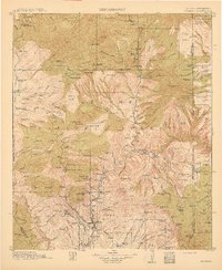
1915 Map of Morenci
USGS Topo · Published 1915About this map
Datil National Forest and Apache National Forest dominate this high-desert landscape, where early twentieth-century settlement is defined by an extensive network of remote cattle operations and forest management outposts. The map reveals the intricate ranching culture of the era through family-named landmarks such as the Double Circle Ranch, Slaughter Ranch, and H U Bar Ranch. These homesteads are scattered across a complex geography of mesas and plateaus, including Sardine Mesa and the expansive Prieto Plateau.
Find a feature on this map
139 named features on this map. Tap any name to fly to it.
Don’t see what you’re looking for? This feature index may not catch every label — zoom into the map to look around manually.
Map Details
Editions of this 1915 Morenci Map
3 editions found
Other maps of this area

1902 · Clifton
USGS Topo · 1:62,500

1910 · Mogollon
USGS Topo · 1:125,000

1912 · Mogollon
USGS Topo · 1:125,000

1913 · Morenci
USGS Topo · 1:125,000

1915 · Morenci
USGS Topo · 1:125,000

1915 · Reserve
USGS Topo · 1:125,000

1918 · Reserve
USGS Topo · 1:125,000

1922 · Nutrioso
USGS Topo · 1:125,000

1954 · Silver City
USGS Topo · 1:250,000

1954 · Clifton
USGS Topo · 1:250,000