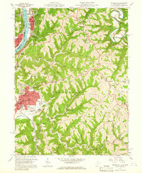
1960 Map of Moundsville
USGS Topo · Published 1966About this map
Moundsville sits as the focal point of this 1960 survey, dominated by industrial and institutional infrastructure along the eastern bank of the Ohio River. The city is notable for housing the State Penitentiary and the Grave Creek Indian Mound Museum, while the nearby Camp Fairchance (Prison Camp) and Prison Farms illustrate the significant footprint of the penal system in Marshall County at this time. Northward, the river valley tightens at The Narrows, where the Baltimore and Ohio railroad and highway infrastructure are squeezed between the river and steep hillsides. This topography forced a dense string of riverfront settlements including McMechen, Glendale, and Benwood. Beyond the industrial valley, the map reveals a dissected landscape of ridges and hollows, such as Waymans Ridge and Blairs Ridge, where small communities like Limestone and Sherrard maintained a separate, rural character centered around country churches and district schools.
Find a feature on this map
78 named features on this map. Tap any name to fly to it.
Don’t see what you’re looking for? This feature index may not catch every label — zoom into the map to look around manually.
Map Details
Editions of this 1960 Moundsville Map
4 editions found
Other maps of this area

1902 · Wheeling
USGS Topo · 1:62,500

1904 · Cameron
USGS Topo · 1:62,500

1905 · Clarington
USGS Topo · 1:62,500

1905 · St. Clairsville
USGS Topo · 1:62,500

1935 · Cameron
USGS Topo · 1:62,500

1935 · Clarington
USGS Topo · 1:62,500

1935 · Wheeling
USGS Topo · 1:62,500

1940 · Clarington
USGS Topo · 1:62,500

1942 · Cameron
USGS Topo · 1:62,500

1942 · Wheeling
USGS Topo · 1:62,500