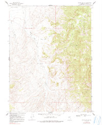
1969 Map of Mount Airy NE
USGS Topo · Published 1991About this map
Antelope Creek and White Sage Creek drain into the broad expanse of Antelope Valley on this Nevada survey based on 1966 aerial photography. The terrain is defined by the sharp transition from the level White Sage Flat to the high elevations of Ravenwood. Evidence of mid-century land use and mineral exploration is scattered throughout the hills and canyons, notably at the White Sage Canyon Corral and various Prospects. Critical water sources in this arid environment are carefully documented, including Cadro Spring, a well, and a seep. The presence of several prospect sites and a Mine in the southeastern quadrant suggests a period of active geological investigation and small-scale extraction. Unimproved 4wd tracks provide the only passage through this territory, linking the valley floor to the remote heights.
Find a feature on this map
18 named features on this map. Tap any name to fly to it.
Don’t see what you’re looking for? This feature index may not catch every label — zoom into the map to look around manually.
Map Details
Editions of this 1969 Mount Airy NE Map
2 editions found
Other maps of this area

1955 · Millett
USGS Topo · 1:250,000

1959 · Millett
USGS Topo · 1:250,000

1969 · Manhattan Mtn
USGS Topo · 1:24,000

1969 · Gilbert Creek SE
USGS Topo · 1:24,000

1969 · Mount Airy
USGS Topo · 1:24,000

1969 · Vigus Butte
USGS Topo · 1:24,000

1969 · Gilbert Creek SW
USGS Topo · 1:24,000

1969 · Vigus Butte NW
USGS Topo · 1:24,000

1969 · Mount Airy NW
USGS Topo · 1:24,000

1969 · Mount Airy NE
USGS Topo · 1:24,000