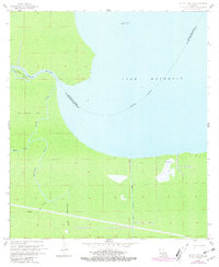
1962 Map of Mount Airy NE
USGS Topo · Published 1981About this map
The low-lying wetlands of Lake Maurepas and the surrounding cypress-tupelo swamp define this section of the Louisiana coast in the early 1960s. The map illustrates a complex network of waterways, including the broad Blind River and meandering channels like Mississippi Bayou and Dutch Bayou. Human industry is etched into this aqueous landscape through the presence of the Lake Maurepas Oil Field and an Old Railroad Grade that speaks to earlier logging or transport efforts through the marsh. This 1962 topography also captures the precise, man-made straightness of the Reserve Relief Canal, contrasting with the winding natural bayous. The boundary between Livingston Parish and St. John the Baptist Parish is noted as an indefinite line through the open water, reflecting the shifting nature of the shoreline and the challenge of surveying this saturated terrain.
Find a feature on this map
15 named features on this map. Tap any name to fly to it.
Don’t see what you’re looking for? This feature index may not catch every label — zoom into the map to look around manually.
Map Details
Editions of this 1962 Mount Airy NE Map
4 editions found
Other maps of this area

1892 · Mount Airy
USGS Topo · 1:62,500

1892 · Bonnet Carre
USGS Topo · 1:62,500

1934 · Springfield
USGS Topo · 1:62,500

1935 · Laplace
USGS Topo · 1:31,680

1935 · Ponchatoula
USGS Topo · 1:62,500

1936 · Ruddock
USGS Topo · 1:31,680

1936 · Bonnet Carre
USGS Topo · 1:62,500

1939 · Ponchatoula
USGS Topo · 1:62,500

1939 · Springfield
USGS Topo · 1:62,500

1946 · North of Garyville
USGS Topo · 1:31,680