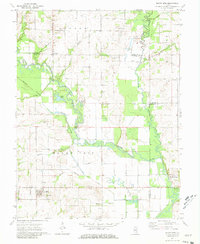
1971 Map of Mount Erie
USGS Topo · Published 1981About this map
The Little Wabash River meanders across this rural landscape, defining the boundaries where Wayne, Richland, and Edwards Counties converge. The village of Mount Erie serves as the primary upland settlement, flanked by numerous family burial grounds including Crews Cem, Scott Cem, and Moutray Cem. This 1970s aerial survey reveals an environment shaped by water management, where the West Side Diversion Ditch and Maple Grove Diversion Ditch cut through the bottomlands to control the flow of the Calhoun Fork River. Local history is preserved in landmarks such as the Forest Ridge Ch, the rural school at Seminary, and the community of Wynoose. The map documents a transition in land use, showing scattered oil wells interspersed with agricultural fields and winding sloughs like Moutray Slough and Goose Pond.
Find a feature on this map
43 named features on this map. Tap any name to fly to it.
Don’t see what you’re looking for? This feature index may not catch every label — zoom into the map to look around manually.
Map Details
Editions of this 1971 Mount Erie Map
2 editions found
Other maps of this area

1943 · Albion
USGS Topo · 1:62,500

1946 · Albion
USGS Topo · 1:62,500

1948 · Fairfield
USGS Topo · 1:62,500

1948 · Flora
USGS Topo · 1:62,500

1949 · Olney
USGS Topo · 1:62,500

1949 · Flora
USGS Topo · 1:62,500

1958 · Belleville
USGS Topo · 1:250,000

1962 · Belleville
USGS Topo · 1:250,000

1970 · Clay City
USGS Topo · 1:24,000

1970 · Enterprise
USGS Topo · 1:24,000