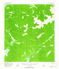
1954 Map of Mount Hayes D-1
USGS Topo · Published 1962About this map
Lake George and the surrounding wilderness of interior Alaska appear here as they were documented in the mid-1950s. This survey, primarily based on photogrammetric methods from 1954 aerial photography, illustrates a landscape defined by its hydrography and elevation rather than human settlement. The drainage patterns of George Creek and Sand Creek carve through the terrain, leading toward the collection point at Sand Lake.
Find a feature on this map
5 named features on this map. Tap any name to fly to it.
Don’t see what you’re looking for? This feature index may not catch every label — zoom into the map to look around manually.
Map Details
Editions of this 1954 Mount Hayes D-1 Map
5 editions found
Other maps of this area

1949 · Tanacross
USGS Topo · 1:250,000

1950 · Tanacross
USGS Topo · 1:250,000

1950 · Mount Hayes
USGS Topo · 1:250,000

1950 · Big Delta
USGS Topo · 1:250,000

1951 · Big Delta
USGS Topo · 1:250,000

1951 · Mount Hayes
USGS Topo · 1:250,000

1951 · Eagle
USGS Topo · 1:250,000

1954 · Mount Hayes D-2
USGS Topo · 1:63,360

1954 · Tanacross C-6
USGS Topo · 1:63,360

1954 · Mount Hayes D-1
USGS Topo · 1:63,360