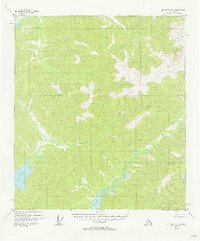
1954 Map of Mt. Hayes D-1
USGS Topo · Published 1962About this map
Lake George and its surrounding watershed dominate this mid-century topographic record of the Alaska interior. The landscape is defined by the braided path of George Creek and the intricate drainage patterns of Sand Lake and Sand Creek. Based on 1954 aerial photography, the survey illustrates a wilderness area devoid of established roads or trails during this period. The terrain is precisely measured through triangulation stations such as VABM George 3360, which provides a literal high point for the geographic data. This map captures the region in a state of natural transition, showing the complex interaction between glacial runoff and the formation of temporary water bodies and creek beds before later development altered these remote drainages.
Find a feature on this map
5 named features on this map. Tap any name to fly to it.
Don’t see what you’re looking for? This feature index may not catch every label — zoom into the map to look around manually.
Map Details
Editions of this 1954 Mt. Hayes D-1 Map
5 editions found
Other maps of this area

1949 · Tanacross
USGS Topo · 1:250,000

1950 · Tanacross
USGS Topo · 1:250,000

1950 · Mount Hayes
USGS Topo · 1:250,000

1950 · Big Delta
USGS Topo · 1:250,000

1951 · Big Delta
USGS Topo · 1:250,000

1951 · Mount Hayes
USGS Topo · 1:250,000

1951 · Eagle
USGS Topo · 1:250,000

1954 · Mount Hayes D-2
USGS Topo · 1:63,360

1954 · Tanacross C-6
USGS Topo · 1:63,360

1954 · Mount Hayes D-1
USGS Topo · 1:63,360