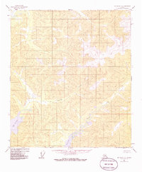
1954 Map of Mt. Hayes D-1
USGS Topo · Published 1986About this map
Lake George and the surrounding high-altitude terrain of the Alaska Range dominate this mid-century topographic study, capturing a landscape defined by glacial hydrology and steep elevation changes. The waterway of George Creek cuts through the central portion of the quadrangle, serving as a primary drainage for the surrounding peaks. In the lower reaches, Sand Lake and the meandering path of Sand Creek illustrate the complex depositional environment common to this region's glacial valleys. This 1954 survey, which underwent minor revision in 1985, records the area as it existed before any significant road infrastructure or human settlement appeared on the official record. The absence of trails and structures emphasizes the wilderness character of the Southeast Fairbanks region during the post-war era, providing a baseline for environmental historians and researchers studying the shifting shorelines of Alaskas glacial lakes.
Find a feature on this map
4 named features on this map. Tap any name to fly to it.
Don’t see what you’re looking for? This feature index may not catch every label — zoom into the map to look around manually.
Map Details
Editions of this 1954 Mt. Hayes D-1 Map
5 editions found
Other maps of this area

1949 · Tanacross
USGS Topo · 1:250,000

1950 · Tanacross
USGS Topo · 1:250,000

1950 · Mount Hayes
USGS Topo · 1:250,000

1950 · Big Delta
USGS Topo · 1:250,000

1951 · Big Delta
USGS Topo · 1:250,000

1951 · Mount Hayes
USGS Topo · 1:250,000

1951 · Eagle
USGS Topo · 1:250,000

1954 · Mount Hayes D-2
USGS Topo · 1:63,360

1954 · Tanacross C-6
USGS Topo · 1:63,360

1954 · Mount Hayes D-1
USGS Topo · 1:63,360