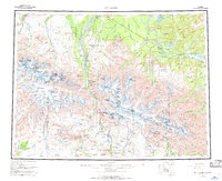
1955 Map of Mount Hayes
USGS Topo · Published 1970About this map
Fort Greely dominates the northern landscape near the confluence of the Delta River and the Tanana River in this mid-century survey. The terrain transitions from the high peaks of the Granite Mountains and massive glaciers surrounding Mount Hayes to the braided river valleys and sloughs below. Transportation is a primary theme of the map, with the Alaska Highway and Richardson Highway intersecting as vital lifelines for the region. Small settlements and specialized locations like Black Rapids, Donnelly, and the Dot Lake Indian Village are plotted alongside historical routes such as the Tractor Trail. The intersection of modern infrastructure and indigenous presence is clear, evidenced by the inclusion of the Dot Lake Indian Village along the highway and the remote Dempsey station to the south, highlighting the area's strategic and logistical importance during the post-war era.
Find a feature on this map
115 named features on this map. Tap any name to fly to it.
Don’t see what you’re looking for? This feature index may not catch every label — zoom into the map to look around manually.
Map Details
Editions of this 1955 Mount Hayes Map
4 editions found

Other maps of this area

1948 · Tanacross A-6
USGS Topo · 1:63,360

1949 · Tanacross
USGS Topo · 1:250,000

1949 · Mount Hayes A-4
USGS Topo · 1:63,360

1949 · Gulkana D-3
USGS Topo · 1:63,360

1949 · Nabesna D-6
USGS Topo · 1:63,360

1949 · Big Delta A-6
USGS Topo · 1:63,360

1949 · Tanacross B-6
USGS Topo · 1:63,360

1949 · Fairbanks A-1
USGS Topo · 1:63,360

1949 · Healy A-1
USGS Topo · 1:63,360

1949 · Healy D-1
USGS Topo · 1:63,360