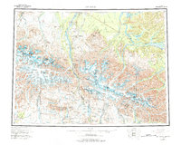
1955 Map of Mount Hayes
USGS Topo · Published 1977About this map
Mount Hayes stands at the center of this 1955 survey, part of a massive glacial and mountainous corridor within the Alaska Range. The landscape is defined by the flow of massive ice fields like the Susitna Glacier and Black Rapids Glacier, which feed the complex river systems of the Delta River and Tanana River. Human infrastructure is concentrated along the Richardson Highway, which serves as the primary artery connecting high-latitude outposts.
Find a feature on this map
67 named features on this map. Tap any name to fly to it.
Don’t see what you’re looking for? This feature index may not catch every label — zoom into the map to look around manually.
Map Details
Editions of this 1955 Mount Hayes Map
4 editions found

Other maps of this area

1948 · Tanacross A-6
USGS Topo · 1:63,360

1949 · Tanacross
USGS Topo · 1:250,000

1949 · Mount Hayes A-4
USGS Topo · 1:63,360

1949 · Gulkana D-3
USGS Topo · 1:63,360

1949 · Nabesna D-6
USGS Topo · 1:63,360

1949 · Big Delta A-6
USGS Topo · 1:63,360

1949 · Tanacross B-6
USGS Topo · 1:63,360

1949 · Fairbanks A-1
USGS Topo · 1:63,360

1949 · Healy A-1
USGS Topo · 1:63,360

1949 · Healy D-1
USGS Topo · 1:63,360