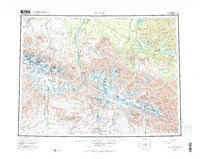
1955 Map of Mount Hayes
USGS Topo · Published 1977About this map
Fort Greely dominates the northern landscape of this mid-century survey, situated at the strategic junction where the Tanana River meets the glacial outwash of the Delta River. The map captures a transition in Alaskan transportation history, showing the established Richardson Highway and Alaska Highway alongside the newly constructed Denali Highway and the path of the Trans-Alaska Pipeline. In the high country to the south, the massive glaciers of Mount Hayes and Mount Moffit feed the complex river systems that defined early travel in the interior.
Find a feature on this map
138 named features on this map. Tap any name to fly to it.
Don’t see what you’re looking for? This feature index may not catch every label — zoom into the map to look around manually.
Map Details
Editions of this 1955 Mount Hayes Map
4 editions found

Other maps of this area

1948 · Tanacross A-6
USGS Topo · 1:63,360

1949 · Tanacross
USGS Topo · 1:250,000

1949 · Mount Hayes A-4
USGS Topo · 1:63,360

1949 · Gulkana D-3
USGS Topo · 1:63,360

1949 · Nabesna D-6
USGS Topo · 1:63,360

1949 · Big Delta A-6
USGS Topo · 1:63,360

1949 · Tanacross B-6
USGS Topo · 1:63,360

1949 · Fairbanks A-1
USGS Topo · 1:63,360

1949 · Healy A-1
USGS Topo · 1:63,360

1949 · Healy D-1
USGS Topo · 1:63,360