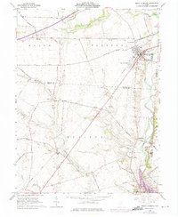
1961 Map of Mount Sterling
USGS Topo · Published 1975About this map
Mount Sterling serves as the primary hub of this 1960s Central Ohio landscape, where the Baltimore and Ohio railroad cuts diagonally across the fertile plains of the Virginia Military District. The map details a rural transition period, where established farming communities like Madison Mills and Chenoweth are documented alongside newer developments such as Burr Oaks Heights. The terrain is defined by the winding course of Deer Creek and its many tributaries, including North Fork Paint Creek and Sugar Run, which shaped the early settlement patterns and road networks of Madison, Fayette, and Pickaway counties.
Find a feature on this map
59 named features on this map. Tap any name to fly to it.
Don’t see what you’re looking for? This feature index may not catch every label — zoom into the map to look around manually.
Map Details
Editions of this 1961 Mount Sterling Map
2 editions found
Other maps of this area

1906 · Mt Sterling
USGS Topo · 1:62,500

1907 · London
USGS Topo · 1:62,500

1911 · Era
USGS Topo · 1:62,500

1913 · Era
USGS Topo · 1:62,500

1923 · West Columbus
USGS Topo · 1:62,500

1925 · West Columbus
USGS Topo · 1:62,500

1943 · Era
USGS Topo · 1:62,500

1947 · Columbus
USGS Topo · 1:250,000

1955 · Harrisburg
USGS Topo · 1:24,000
1958 · Five Points
USGS Topo · 1:24,000