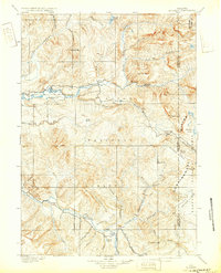
1902 Map of Mt Leidy
USGS Topo · Published 1932About this map
Togwotee Pass stands as a vital high-altitude crossing point where the Continental Divide winds through the high country of what was then the Teton National Forest. This 1899 survey, updated for the early 20th century, documents a landscape shaped by the headwaters of the Gros Ventre River and the Buffalo Fork. The mapping details an era before modern highway infrastructure, where the Sheridan Trail provided essential passage across the divide near Lava Mt. and Pilot Knob. Localized geographic markers like Dick Turpin Meadow and the camp at Cole Hollow indicate early pioneer and pastoral use of these high basins. The topography is defined by prominent peaks including Mt. Leidy, Terrace Mt., and Breccia Pk., illustrating the complex drainages of Blackrock Creek and Spread Creek that feed the region's major river systems.
Find a feature on this map
54 named features on this map. Tap any name to fly to it.
Don’t see what you’re looking for? This feature index may not catch every label — zoom into the map to look around manually.
Map Details
Editions of this 1902 Mt Leidy Map
5 editions found

Other maps of this area

1885 · Lake
USGS Topo · 1:125,000

1886 · Shoshone
USGS Topo · 1:125,000

1888 · Shoshone
USGS Topo · 1:125,000

1893 · Ishawooa
USGS Topo · 1:125,000

1895 · Shoshone
USGS Topo · 1:125,000

1895 · Ishawooa
USGS Topo · 1:125,000

1895 · Lake
USGS Topo · 1:125,000

1896 · Lake
USGS Topo · 1:125,000

1899 · Ishawooa
USGS Topo · 1:125,000

1899 · Grand Teton
USGS Topo · 1:125,000