1948 Map of Mud Creek
USGS Topo · Published 1977About this map
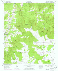
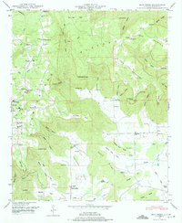
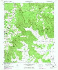
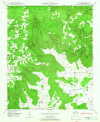
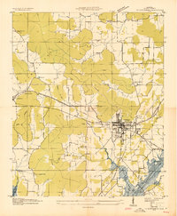
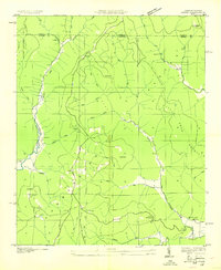
The Cumberland Plateau dominates this Jackson County landscape, where the deeply incised valleys of the Mud Creek watershed meet the high, wooded benches of Crow Mountain. Settled communities such as Cornelison and Kyles occupy the lower elevations, while the plateau top is defined by features like Post Oak Flat and The Buzzard Roost. This 1948 survey, updated with 1975 revisions, captures a network of rural institutions including Skyline Sch, New Life Ch, and Holland Chapel, alongside numerous family burial grounds like Sanders Cem and Bynum Cem. The map reveals a land dictated by topography, where travel is funneled through passes like Moody Gap and development follows the floor of Maynard Cove. Natural landmarks like Blowing Cave and Flag Spring point to the karst geography underlying this portion of the Tennessee Valley Authority's mapping area.
Find a feature on this map
68 named features on this map. Tap any name to fly to it.
Don’t see what you’re looking for? This feature index may not catch every label — zoom into the map to look around manually.
Map Details
Editions of this 1948 Mud Creek Map
5 editions found

Other maps of this area

1886 · Stevenson
USGS Topo · 1:125,000

1888 · Scottsboro
USGS Topo · 1:125,000

1892 · Scottsboro
USGS Topo · 1:125,000

1892 · Stevenson
USGS Topo · 1:125,000

1895 · Stevenson
USGS Topo · 1:125,000
1936 · Scottsboro
USGS Topo · 1:24,000

1936 · Wannville
USGS Topo · 1:24,000

1936 · Mud Creek
USGS Topo · 1:24,000
1936 · Hytop
USGS Topo · 1:24,000

1936 · Princeton
USGS Topo · 1:24,000