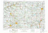
1953 Map of Muncie
USGS Topo · Published 1976About this map
Muncie serves as a central hub in this detailed mid-century layout of East Central Indiana and Western Ohio, an era defined by a dense grid of railroads and the emergence of the interstate highway system. The landscape is characterized by the headwaters of the Wabash River, White River, and Mississinewa River, which carved the paths for early settlement and industrial centers like Marion, Anderson, and Lima. This survey captures a specific moment of academic and civic growth, highlighting institutions such as Ball State University and Taylor University, alongside a network of rural landmarks from Bethel Church to the Beech Grove Cem.
Find a feature on this map
307 named features on this map. Tap any name to fly to it.
Don’t see what you’re looking for? This feature index may not catch every label — zoom into the map to look around manually.
Map Details
Editions of this 1953 Muncie Map
5 editions found

Other maps of this area

1904 · Springfield
USGS Topo · 1:62,500

1904 · Dayton
USGS Topo · 1:62,500

1905 · Brookville
USGS Topo · 1:62,500

1906 · Dayton
USGS Topo · 1:62,500

1906 · Springfield
USGS Topo · 1:62,500

1906 · Lima
USGS Topo · 1:62,500

1906 · Columbus Grove
USGS Topo · 1:62,500

1907 · Bluffton
USGS Topo · 1:62,500

1908 · Columbus Grove
USGS Topo · 1:62,500

1908 · Ottawa
USGS Topo · 1:62,500