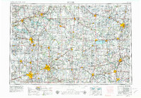
1953 Map of Muncie
USGS Topo · Published 1979About this map
Muncie and Anderson anchor the southwestern portion of this map, which captures the industrial and agricultural heart of the mid-century Midwest. The landscape is defined by the dense network of rail lines including the Pennsylvania RR, Nickel Plate RR, and New York Central RR, which served the bustling manufacturing centers of Marion, Lima, and Piqua. These rail corridors cut across the glacial drainages of the Wabash and Mississinewa valleys, connecting numerous county seats marked by landmarks like the Jay County Courthouse and the Adams County Courthouse.
Find a feature on this map
368 named features on this map. Tap any name to fly to it.
Don’t see what you’re looking for? This feature index may not catch every label — zoom into the map to look around manually.
Map Details
Editions of this 1953 Muncie Map
5 editions found

Other maps of this area

1904 · Springfield
USGS Topo · 1:62,500

1904 · Dayton
USGS Topo · 1:62,500

1905 · Brookville
USGS Topo · 1:62,500

1906 · Dayton
USGS Topo · 1:62,500

1906 · Springfield
USGS Topo · 1:62,500

1906 · Lima
USGS Topo · 1:62,500

1906 · Columbus Grove
USGS Topo · 1:62,500

1907 · Bluffton
USGS Topo · 1:62,500

1908 · Columbus Grove
USGS Topo · 1:62,500

1908 · Ottawa
USGS Topo · 1:62,500