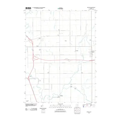
2010 Map of Nevada
USGS Topo · Published 2010About this map
Broken Sword Creek and the Sandusky River dominate the drainage of this Wyandot County landscape, where the village of Nevada serves as a central hub. The map reveals a high density of small family and local burying grounds, including the Old Rock Run Cemetery, Salem Cemetery, and Gilliland Cemetery. Of particular interest are the sites related to Indigenous history near the river, specifically the Wyandot Indian Cemetery and the two Pipetown Indian Number One Cemetery and Pipetown Indian Number Two Cemetery locations.
Find a feature on this map
57 named features on this map. Tap any name to fly to it.
Don’t see what you’re looking for? This feature index may not catch every label — zoom into the map to look around manually.
Map Details
Editions of this 2010 Nevada Map
This is the sole edition of this map. No revisions or reprints were ever made.
Other maps of this area

1903 · Marion
USGS Topo · 1:62,500

1905 · Marion
USGS Topo · 1:62,500

1906 · Sycamore
USGS Topo · 1:62,500

1907 · Upper Sandusky
USGS Topo · 1:62,500

1915 · La Rue
USGS Topo · 1:62,500

1950 · Marion
USGS Topo · 1:250,000

1960 · Sycamore
USGS Topo · 1:24,000

1960 · Oceola
USGS Topo · 1:24,000
1960 · Lykens
USGS Topo · 1:24,000

1960 · Nevada
USGS Topo · 1:24,000