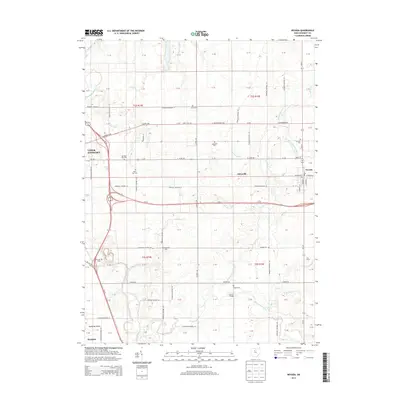
2013 Map of Nevada
USGS Topo · Published 2013About this map
The Sandusky River winds through this Wyandot County landscape, anchoring a region defined by its rich agricultural heritage and early village settlements. On the western edge, the outskirts of Upper Sandusky appear near the junction of Us-23 and Us-30, while the village of Nevada occupies the eastern boundary, complete with its local Po and school site. The map captures a high density of rural burial grounds, such as Salem Cem, Gilliland Cem, and McClain Cem, which provide essential clues for genealogists tracing family histories in the townships of t2s r14e and t3s r15e. Smaller named locales like Edenville and the Sandusky Plains near Harpster further illustrate the distribution of 19th and 20th-century farmsteads. Tributaries like Broken Sword Creek and Cranberry Run intersect the grid of township roads, marking the historic drainage patterns of this fertile Ohio territory.
Find a feature on this map
67 named features on this map. Tap any name to fly to it.
Don’t see what you’re looking for? This feature index may not catch every label — zoom into the map to look around manually.
Map Details
Editions of this 2013 Nevada Map
This is the sole edition of this map. No revisions or reprints were ever made.
Other maps of this area

1903 · Marion
USGS Topo · 1:62,500

1905 · Marion
USGS Topo · 1:62,500

1906 · Sycamore
USGS Topo · 1:62,500

1907 · Upper Sandusky
USGS Topo · 1:62,500

1915 · La Rue
USGS Topo · 1:62,500

1950 · Marion
USGS Topo · 1:250,000

1960 · Sycamore
USGS Topo · 1:24,000

1960 · Oceola
USGS Topo · 1:24,000
1960 · Lykens
USGS Topo · 1:24,000

1960 · Nevada
USGS Topo · 1:24,000