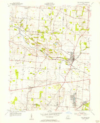
1955 Map of New Carlisle
USGS Topo · Published 1956About this map
New Carlisle serves as the primary hub of this mid-century survey, situated at the intersection of New Carlisle Road and New York Road. The agricultural landscape is divided by the meandering Honey Creek, which flows westward past the New Carlisle Cem and the Sewage Disposal facility. To the south, the planned community of Crystal Lakes borders Mud Creek, while the historic National Road cuts across the lower half of the quadrangle, linking the settlement of Brandt with the surrounding countryside.
Find a feature on this map
75 named features on this map. Tap any name to fly to it.
Don’t see what you’re looking for? This feature index may not catch every label — zoom into the map to look around manually.
Map Details
Editions of this 1955 New Carlisle Map
4 editions found
Other maps of this area

1904 · Springfield
USGS Topo · 1:62,500

1904 · Dayton
USGS Topo · 1:62,500

1906 · Dayton
USGS Topo · 1:62,500

1906 · Springfield
USGS Topo · 1:62,500

1914 · Troy
USGS Topo · 1:62,500

1914 · St. Paris
USGS Topo · 1:62,500

1916 · St. Paris
USGS Topo · 1:62,500

1944 · St. Paris
USGS Topo · 1:62,500

1944 · Troy
USGS Topo · 1:62,500

1947 · Columbus
USGS Topo · 1:250,000