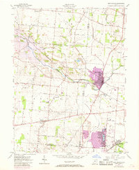
1955 Map of New Carlisle
USGS Topo · Published 1968About this map
New Carlisle serves as the primary hub of this landscape, situated at the intersection of a developing road network and the Penn Central railroad line. The mid-century character of the area is defined by established township boundaries such as Elizabeth and Bethel, where small rural settlements like Brandt and Medway anchor the surrounding agricultural land. A significant portion of the western terrain is marked as subject to controlled inundation by the Taylorsville Dam, reflecting the managed water systems of the Great Miami River Base.
Find a feature on this map
54 named features on this map. Tap any name to fly to it.
Don’t see what you’re looking for? This feature index may not catch every label — zoom into the map to look around manually.
Map Details
Editions of this 1955 New Carlisle Map
4 editions found
Other maps of this area

1904 · Springfield
USGS Topo · 1:62,500

1904 · Dayton
USGS Topo · 1:62,500

1906 · Dayton
USGS Topo · 1:62,500

1906 · Springfield
USGS Topo · 1:62,500

1914 · Troy
USGS Topo · 1:62,500

1914 · St. Paris
USGS Topo · 1:62,500

1916 · St. Paris
USGS Topo · 1:62,500

1944 · St. Paris
USGS Topo · 1:62,500

1944 · Troy
USGS Topo · 1:62,500

1947 · Columbus
USGS Topo · 1:250,000