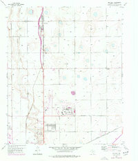
1956 Map of New Deal
USGS Topo · Published 1977About this map
New Deal serves as the central hub of this High Plains landscape, situated along the corridor of the Atchison Topeka and Santa Fe railroad. The map illustrates a period of mid-century growth as the Lubbock metropolitan area expanded northward. This expansion is most evident in the development of the Lubbock Regional Airport and the neighboring City of Lubbock Industrial Area, which anchor the southern portion of the sheet. The terrain is characterized by the winding path of Blackwater Draw, where localized activity is marked by Gravel Pits and the recreational grounds of the Lubbock Country Club. In the eastern section, the small settlement of Liberty stands near the intersection of the secondary rail line, the Fort Worth and Denver, showing the vital role of transportation networks in the region's agricultural and industrial layout.
Find a feature on this map
10 named features on this map. Tap any name to fly to it.
Don’t see what you’re looking for? This feature index may not catch every label — zoom into the map to look around manually.
Map Details
Editions of this 1956 New Deal Map
3 editions found
Other maps of this area

1954 · Lubbock
USGS Topo · 1:250,000

1956 · Shallowater
USGS Topo · 1:24,000

1956 · New Deal
USGS Topo · 1:24,000

1957 · Lubbock East
USGS Topo · 1:24,000

1957 · Lubbock West
USGS Topo · 1:24,000

1957 · Lubbock
USGS Topo · 1:62,500

1957 · Abernathy
USGS Topo · 1:62,500

1965 · Buffalo Springs Lake
USGS Topo · 1:24,000

1965 · Idalou
USGS Topo · 1:24,000

1965 · Heckville
USGS Topo · 1:24,000