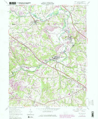
1957 Map of New Galilee
USGS Topo · Published 1979About this map
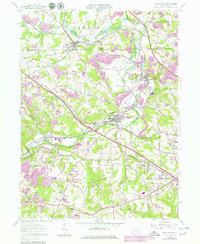
Enon Valley and New Galilee anchor this landscape of western Pennsylvania as it appeared in the mid-20th century, where the industrial legacy of the region is evident in the numerous Strip Mine operations and Brick Kilns near Darlington. The terrain is deeply etched by the North Fork and Little Beaver Creek, which define the drainage patterns and historical settlement corridors. Significant rail infrastructure, including the Conrail and the Youngstown And Southern lines, connects these rural boroughs to the larger regional economy. Local genealogy is well-represented through scattered landmarks such as the Little Beaver Cem, White Ch, and Rocky Spring Cem, alongside community institutions like the County Sch. The 1970s updates reveal more modern additions to the landscape, such as a Drive-in Theater and the expansion of the Beaver County Airport in Chippewa. This survey illustrates the transition from a heavy resource-extraction economy toward more contemporary recreational and suburban uses, including the Black Hawk Golf Course and preserved areas within State Game Lands No 285.
Find a feature on this map
46 named features on this map. Tap any name to fly to it.
Don’t see what you’re looking for? This feature index may not catch every label — zoom into the map to look around manually.
Map Details
Editions of this 1957 New Galilee Map
5 editions found
Other maps of this area

1901 · Beaver
USGS Topo · 1:62,500

1902 · New Castle
USGS Topo · 1:62,500

1904 · Newcastle
USGS Topo · 1:62,500

1904 · Wellsville
USGS Topo · 1:62,500

1904 · Beaver
USGS Topo · 1:62,500

1907 · Columbiana
USGS Topo · 1:62,500

1909 · Columbiana
USGS Topo · 1:62,500

1937 · Wellsville
USGS Topo · 1:62,500

1944 · Wellsville
USGS Topo · 1:62,500

1951 · Canton
USGS Topo · 1:250,000