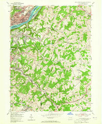
1953 Map of New Kensington East
USGS Topo · Published 1965About this map
Industrial and suburban expansion along the Allegheny River defines the landscape during the early 1950s, particularly within the heavy manufacturing corridor of Natrona, Brackenridge, and Tarentum. Above the river, the planned growth of Natrona Heights contrasts with the undulating rural hills of Lower Burrell and Upper Burrell. The cultural life of these communities is evident in the dense clustering of religious and educational institutions, such as St Ladislaus Ch, Blessed Sacrament Sch, and Har Brack High Sch. Away from the urban riverfront, the map captures a shift toward recreational and extraction-based land use. Small-scale coal operations, indicated by a Strip Mine and various Mine Dump sites, share the countryside with leisure spots like Rabbit Foot Lake, a local Golf Course, and Camp Jo-Ann.
Find a feature on this map
67 named features on this map. Tap any name to fly to it.
Don’t see what you’re looking for? This feature index may not catch every label — zoom into the map to look around manually.
Map Details
Editions of this 1953 New Kensington East Map
4 editions found
Other maps of this area

1904 · Mc Keesport
USGS Topo · 1:62,500

1904 · Greensburg
USGS Topo · 1:62,500

1906 · Greensburg
USGS Topo · 1:62,500

1907 · Pittsburg
USGS Topo · 1:62,500

1907 · Freeport
USGS Topo · 1:62,500

1908 · New Kensington
USGS Topo · 1:62,500

1909 · Freeport
USGS Topo · 1:62,500

1910 · New Kensington
USGS Topo · 1:62,500

1953 · Pittsburgh
USGS Topo · 1:250,000

1953 · New Kensington East
USGS Topo · 1:24,000