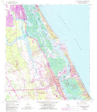
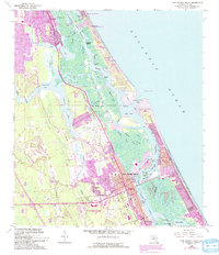
1956 Map of New Smyrna Beach
USGS Topo · Published 1988About this map
The New Smyrna Sugar Mill Ruins State Historic Site stands as a testament to the region's early industrial history, set against a complex landscape of coastal wetlands and growing mid-century settlements. This survey, based on 1950s data with later 1980s updates, documents the coastal evolution of New Smyrna Beach and its surrounding communities. The intricate network of tidal waterways, including the Halifax River, Spruce Creek, and the North Indian River, is bifurcated by the Intracoastal Waterway, which serves as the primary maritime artery.
Find a feature on this map
52 named features on this map. Tap any name to fly to it.
Don’t see what you’re looking for? This feature index may not catch every label — zoom into the map to look around manually.
Map Details
Editions of this 1956 New Smyrna Beach Map
6 editions found

Other maps of this area

1937 · Port Orange
USGS Topo · 1:48,000

1943 · Port Orange
USGS Topo · 1:62,500

1944 · Port Orange
USGS Topo · 1:62,500

1950 · Ariel
USGS Topo · 1:24,000

1950 · Edgewater
USGS Topo · 1:24,000

1952 · Samsula
USGS Topo · 1:24,000

1952 · Daytona Beach
USGS Topo · 1:24,000

1954 · Daytona Beach
USGS Topo · 1:250,000

1955 · Orlando
USGS Topo · 1:250,000

1956 · Port Orange
USGS Topo · 1:24,000