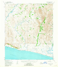
1950 Map of Nome C-2
USGS Topo · Published 1964About this map
Sinuk River and the Cripple River dominate this coastal Seward Peninsula landscape as they flow toward the Norton Sound. Mapped from 1950 aerial photography, the terrain is characterized by a network of braided streams and gulches, including Nugget Gulch and Short Gulch, draining the highlands. Local industrial activity is evidenced by the Sunset Mine (Tailings) located in the eastern portion of the sheet. Transportation is represented by the Winter Trail and several segments of Approximate Alignment roads near the coast. Small-scale exploration and prospecting names are frequent across the drainages, such as Snowshoe Creek, Hungry Creek, and Oregon Creek, suggesting the area's history with the region's mining rushes.
Find a feature on this map
44 named features on this map. Tap any name to fly to it.
Don’t see what you’re looking for? This feature index may not catch every label — zoom into the map to look around manually.
Map Details
Editions of this 1950 Nome C-2 Map
3 editions found
Other maps of this area

1950 · Nome D-2
USGS Topo · 1:63,360

1950 · Nome
USGS Topo · 1:250,000

1950 · Nome B-1
USGS Topo · 1:63,360
1950 · Nome C-3
USGS Topo · 1:63,360

1950 · Nome D-1
USGS Topo · 1:63,360

1950 · Nome D-3
USGS Topo · 1:63,360

1950 · Nome C-2
USGS Topo · 1:63,360

1950 · Nome C-1
USGS Topo · 1:63,360

1951 · Nome
USGS Topo · 1:250,000

1957 · Nome
USGS Topo · 1:250,000