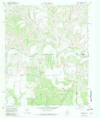
1967 Map of Northfield
USGS Topo · Published 1981About this map
Northfield serves as the primary settlement in this West Texas landscape, situated where the high plains meet the intricate breaks of the North Pease River valley. The map reveals a transition from the agricultural plateaus into a deeply dissected terrain of canyons and creeks. Notable waterways such as Bitter Creek, Mountain Creek, and Cheney Canyon carve through the earth, illustrating the erosion patterns characteristic of the Rolling Plains. The intersection of Hall, Motley, and Cottle counties occurs within these breaks, marked by an Indefinite Boundary along the riverbed. Human activity is focused on ranching and resource extraction, evidenced by scattered Gravel Pits and an Oil Well, while a major Pipeline cuts across the southern reach of the quadrangle. This 1981 update, based on late 1960s surveys, captures the region's enduring rural character and the geography of the Poker Canyon area.
Find a feature on this map
16 named features on this map. Tap any name to fly to it.
Don’t see what you’re looking for? This feature index may not catch every label — zoom into the map to look around manually.
Map Details
Editions of this 1967 Northfield Map
2 editions found
Other maps of this area

1954 · Plainview
USGS Topo · 1:250,000

1958 · Plainview
USGS Topo · 1:250,000

1966 · Fields Canyon
USGS Topo · 1:24,000

1966 · Cee Vee
USGS Topo · 1:24,000

1967 · Tell South
USGS Topo · 1:24,000

1967 · Tell North
USGS Topo · 1:24,000

1967 · Cottonwood Camp
USGS Topo · 1:24,000

1967 · Badger Nest Tank
USGS Topo · 1:24,000

1967 · Turtle Hole Camp
USGS Topo · 1:24,000

1967 · Northfield
USGS Topo · 1:24,000