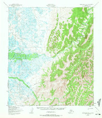
1950 Map of Norton Bay B-4
USGS Topo · Published 1972About this map
The Shaktoolik River meanders across this mid-century landscape, carving through a region defined by seasonal activity and water-based transport. While the map is sparse of permanent towns, it meticulously notes the ephemeral sites of human presence, including a Cabin, Fishing Camp, and Hunting Camp. These small markers represent the traditional land-use patterns of the Norton Bay area, where seasonal subsistence relied on the network of waterways like the Taguomenik River and Anaktuvuk Creek. Overland travel is represented by a solitary Winter Trail, reflecting the logistical realities of the Alaskan interior before the expansion of modern infrastructure. The detailed hydrography, including named features such as Afternoon Creek and Diamond Creek, illustrates a complex drainage system crucial for those navigating the coastal plains and rising foothills.
Find a feature on this map
13 named features on this map. Tap any name to fly to it.
Don’t see what you’re looking for? This feature index may not catch every label — zoom into the map to look around manually.
Map Details
Editions of this 1950 Norton Bay B-4 Map
3 editions found
Other maps of this area

1948 · Norton Bay
USGS Topo · 1:250,000

1950 · Norton Bay B-5
USGS Topo · 1:63,360

1950 · Norton Bay B-4
USGS Topo · 1:63,360

1950 · Norton Bay C-5
USGS Topo · 1:63,360

1950 · Norton Bay B-3
USGS Topo · 1:63,360

1950 · Norton Bay C-3
USGS Topo · 1:63,360

1950 · Norton Bay A-4
USGS Topo · 1:63,360

1950 · Norton Bay A-3
USGS Topo · 1:63,360

1950 · Norton Bay C-4
USGS Topo · 1:63,360

1951 · Norton Bay
USGS Topo · 1:250,000