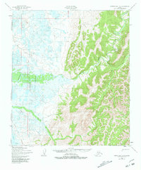
1950 Map of Norton Bay B-4
USGS Topo · Published 1981About this map
The Shaktoolik River dominates this landscape as it meanders through a vast expanse of wetlands and hills south of Norton Bay. Captured during the mid-century via photogrammetric methods, the map reveals a land defined by its seasonal movement and subsistence patterns. A Fishing Camp is situated along the main riverbank, while a Winter Trail cuts across the lowlands, providing a terrestrial link when the ground is frozen. The topography transitions sharply from the swampy reaches of Beeson Slough and the Tagoonmenik River to the upland terrain of Diamond. Numerous small waterways, such as Anaktuvuk Creek and Afternoon Creek, drain the high ground, illustrating the intricate drainage network essential for navigating this roadless Alaskan interior. This survey documents the region's geography before significant modern infrastructure, preserving the location of isolated cabins and traditional transit routes used by local inhabitants.
Find a feature on this map
13 named features on this map. Tap any name to fly to it.
Don’t see what you’re looking for? This feature index may not catch every label — zoom into the map to look around manually.
Map Details
Editions of this 1950 Norton Bay B-4 Map
3 editions found
Other maps of this area

1948 · Norton Bay
USGS Topo · 1:250,000

1950 · Norton Bay B-5
USGS Topo · 1:63,360

1950 · Norton Bay B-4
USGS Topo · 1:63,360

1950 · Norton Bay C-5
USGS Topo · 1:63,360

1950 · Norton Bay B-3
USGS Topo · 1:63,360

1950 · Norton Bay C-3
USGS Topo · 1:63,360

1950 · Norton Bay A-4
USGS Topo · 1:63,360

1950 · Norton Bay A-3
USGS Topo · 1:63,360

1950 · Norton Bay C-4
USGS Topo · 1:63,360

1951 · Norton Bay
USGS Topo · 1:250,000