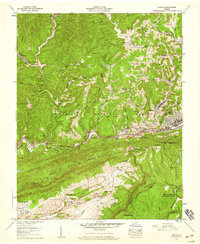
1957 Map of Norton
USGS Topo · Published 1959About this map
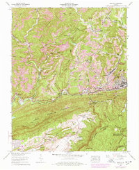
The Powell River and the industrial infrastructure of the Wise County coalfields define this 1957 landscape. Centered on Norton and Big Stone Gap, the map illustrates a complex network of strip mines and railroad connections, including the Louisville and Nashville and Norfolk and Western lines. The terrain is dominated by the steep ridges of Little Stone Mountain and Stone Mountain, where the Trail of the Lonesome Pine weaves through the valley floor. Rural life is deeply etched into the hillsides at Bentley Hollow and Sargent Hollow, marked by a high density of family burial grounds such as Canebatch Cem and Robinett Cem. Along the lower elevations of Powell Valley, a shift toward community and recreation is evident with the Lonesome Pine Country Club, a drive-in theater, and a swimming pool appearing near Legion Memorial Church.
Find a feature on this map
79 named features on this map. Tap any name to fly to it.
Don’t see what you’re looking for? This feature index may not catch every label — zoom into the map to look around manually.
Map Details
Editions of this 1957 Norton Map
8 editions found
Other maps of this area

1890 · Whitesburg
USGS Topo · 1:125,000

1892 · Whitesburg
USGS Topo · 1:125,000

1894 · Estillville
USGS Topo · 1:125,000

1912 · Pound
USGS Topo · 1:48,000

1913 · Oven Fork
USGS Topo · 1:48,000

1914 · Pound
USGS Topo · 1:62,500

1915 · Whitesburg
USGS Topo · 1:62,500

1920 · Wise
USGS Topo · 1:48,000

1921 · Big Stone Gap
USGS Topo · 1:48,000

1921 · Wise
USGS Topo · 1:62,500