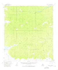
1952 Map of Nulato A-3
USGS Topo · Published 1975About this map
Yuki River meanders through this interior Alaskan wilderness, illustrating a landscape largely defined by its intricate drainage systems and low-lying marshlands as they appeared in the early 1950s. The region is characterized by significant watercourses including the East Fork Yuki River and the Little Mud River, which flow across a terrain of dense contour intervals and scattered swamps. Distinctive landmarks like Round Top and Flat Top provide the only major relief in an area otherwise dominated by the shifting paths of the Mud River. This survey, compiled from 1952 aerial photography, documents a remote section of the Yukon-Koyukuk region before significant modern alteration, preserving the original hydrographic patterns of the Kaiyuh Mountains vicinity.
Find a feature on this map
6 named features on this map. Tap any name to fly to it.
Don’t see what you’re looking for? This feature index may not catch every label — zoom into the map to look around manually.
Map Details
Editions of this 1952 Nulato A-3 Map
3 editions found
Other maps of this area

1945 · Nulato
USGS Topo · 1:250,000

1951 · Ophir
USGS Topo · 1:250,000

1951 · Nulato
USGS Topo · 1:250,000

1952 · Nulato B-2
USGS Topo · 1:63,360

1952 · Nulato A-2
USGS Topo · 1:63,360

1952 · Nulato A-4
USGS Topo · 1:63,360

1952 · Nulato B-3
USGS Topo · 1:63,360

1952 · Nulato B-4
USGS Topo · 1:63,360

1952 · Nulato A-3
USGS Topo · 1:63,360

1952 · Nulato
USGS Topo · 1:250,000