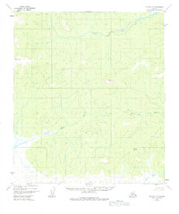
1952 Map of Nulato A-3
USGS Topo · Published 1984About this map
Yuki River meanders across this interior landscape, joined by its East Fork Yuki River as it traverses the remote Yukon-Koyukuk region. The terrain is defined by low-lying wetlands and prominent elevations such as Round Top and Flat Top, providing distinct landmarks for early mid-century navigation. In the southern portion of the sheet, the Little Mud River and Mud River snake through swampy lowlands, reflecting the dynamic hydrologic character of the subarctic wilderness. The lack of roads or established settlements on this 1952 survey highlights the isolation of this territory, where only natural topographic features and the local drainage system dictated travel. One notable landmark, simply labeled Burn, suggests the long-term impact of forest fires on the Alaskan interior's vegetation patterns during this era.
Find a feature on this map
7 named features on this map. Tap any name to fly to it.
Don’t see what you’re looking for? This feature index may not catch every label — zoom into the map to look around manually.
Map Details
Editions of this 1952 Nulato A-3 Map
3 editions found
Other maps of this area

1945 · Nulato
USGS Topo · 1:250,000

1951 · Ophir
USGS Topo · 1:250,000

1951 · Nulato
USGS Topo · 1:250,000

1952 · Nulato B-2
USGS Topo · 1:63,360

1952 · Nulato A-2
USGS Topo · 1:63,360

1952 · Nulato A-4
USGS Topo · 1:63,360

1952 · Nulato B-3
USGS Topo · 1:63,360

1952 · Nulato B-4
USGS Topo · 1:63,360

1952 · Nulato A-3
USGS Topo · 1:63,360

1952 · Nulato
USGS Topo · 1:250,000