
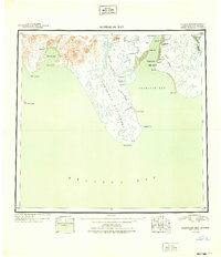
1949 Map of Nushagak Bay
USGS Topo · Published 1949About this map
Commercial fishing and canning operations define the coastlines of Bristol Bay in this mid-century portrait of the region. The map centers on the massive Nushagak Peninsula, terminating at Cape Constantine, which separates the waters of Kulukak Bay from the busy industrial corridor of Nushagak Bay. Along the eastern shore, the infrastructure of the salmon industry is clearly marked at Nushagak Cannery, Clarks Point, and the Old Saltery near the mouth of the Snake River. Small coastal settlements like Kulukak and Quek appear alongside seasonal work sites like Ekuk Spit. Inland, the terrain rises toward Acorn Peak, while the lowlands are dominated by the winding paths of the Igushik River and Weary River. This shaded relief study, derived from 1943 aerial photography, captures the remote landscape before modern development altered these traditional maritime and subsistence sites.
Find a feature on this map
35 named features on this map. Tap any name to fly to it.
Don’t see what you’re looking for? This feature index may not catch every label — zoom into the map to look around manually.
Map Details
Editions of this 1949 Nushagak Bay Map
2 editions found
Other maps of this area

1943 · Ugashik
USGS Topo · 1:250,000

1945 · Nushagak Bay
USGS Topo · 1:250,000

1948 · Ugashik
USGS Topo · 1:250,000

1948 · Nushagak Bay D-4
USGS Topo · 1:63,360

1948 · Nushagak Bay D-3
USGS Topo · 1:63,360

1948 · Nushagak Bay C-4 And C-5
USGS Topo · 1:63,360

1948 · Hagemeister Island C-1
USGS Topo · 1:63,360

1949 · Ugashik
USGS Topo · 1:250,000

1950 · Nushagak Bay B-4
USGS Topo · 1:63,360

1950 · Nushagak Bay C-3
USGS Topo · 1:63,360