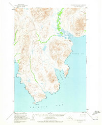
1950 Map of Nushagak Bay D-6
USGS Topo · Published 1972About this map
The Kulukak River snakes through a complex network of coastal wetlands and peaks before emptying into the northern reaches of Bristol Bay. This 1950s-era topography reveals a remote landscape where the only sign of established settlement is noted at Kulukak (Aband), a site positioned on a narrow spit between Kulukak Bay and the river mouth. The presence of high-elevation markers like VABM Amyl 1092 and VABM Kulukak 956 underscores the surveying efforts of the Geological Survey and the U.S. Coast and Geodetic Survey during the mid-century period. To the south, Right Hand Pt defines the coastal boundary between the open waters and the more sheltered Metervik Bay, providing a clear look at the shoreline before modern environmental shifts.
Find a feature on this map
11 named features on this map. Tap any name to fly to it.
Don’t see what you’re looking for? This feature index may not catch every label — zoom into the map to look around manually.
Map Details
Editions of this 1950 Nushagak Bay D-6 Map
3 editions found
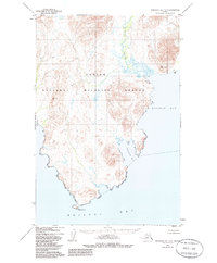
Other maps of this area

1945 · Nushagak Bay
USGS Topo · 1:250,000

1948 · Hagemeister Island C-1
USGS Topo · 1:63,360

1949 · Nushagak Bay
USGS Topo · 1:250,000

1950 · Nushagak Bay D-5
USGS Topo · 1:63,360

1950 · Nushagak Bay D-6
USGS Topo · 1:63,360

1950 · Hagemeister Island D-1
USGS Topo · 1:63,360

1951 · Goodnews
USGS Topo · 1:250,000

1951 · Hagemeister Island
USGS Topo · 1:250,000

1951 · Nushagak Bay
USGS Topo · 1:250,000

1952 · Hagemeister Island C-1
USGS Topo · 1:63,360