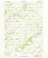
1960 Map of Oceola
USGS Topo · Published 1969About this map
The Old Indian Treaty Boundary slices diagonally across this agricultural landscape, a persistent historical line that predates the standard township grids of Tod and Holmes. Settlement is centered on Oceola and the edge of Nevada, connected by a network of rural roads such as the Bucyrus Nevada Road. The drainage patterns of Broken Sword Creek and the Sandusky River dominate the topography, while industrial activity is noted at the Quarry and Quarry Lake. Local community life is anchored by landmarks like the American Ch, Mt Zion Sch, and Maple Grove Park. The presence of the New York Central and Pennsylvania railroads highlights the importance of rail transit through this portion of Wyandot and Crawford counties during the mid-century era.
Find a feature on this map
28 named features on this map. Tap any name to fly to it.
Don’t see what you’re looking for? This feature index may not catch every label — zoom into the map to look around manually.
Map Details
Editions of this 1960 Oceola Map
3 editions found

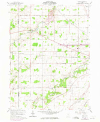
Other maps of this area

1903 · Marion
USGS Topo · 1:62,500

1905 · Marion
USGS Topo · 1:62,500

1906 · Sycamore
USGS Topo · 1:62,500

1913 · Mount Gilead
USGS Topo · 1:62,500

1915 · Bucyrus
USGS Topo · 1:62,500

1916 · Mount Gilead
USGS Topo · 1:62,500

1943 · Bucyrus
USGS Topo · 1:62,500

1943 · Mount Gilead
USGS Topo · 1:62,500

1950 · Marion
USGS Topo · 1:250,000

1960 · Sycamore
USGS Topo · 1:24,000