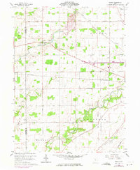
1960 Map of Oceola
USGS Topo · Published 1974About this map
Broken Sword Creek meanders through the heart of this North Central Ohio landscape, where the rural character of the 1960s is preserved in a network of section roads and small communities. The settlement of Oceola sits near Quarry Lake, while the Penn Central rail line cuts diagonally across the northern and central reaches of the map, serving the small community of Spore. This period of the mid-20th century shows the persistence of local institutions, with American Ch, Bethel Cem, and the Mt Zion Sch anchoring the surrounding farmland. The Sandusky River flows through the southern portion of the sheet, where Camp Michael and a Townhall reflect the area's social and civic geography. The presence of the Old Indian Treaty Boundary Road provides a clear historical link to the region's early 19th-century surveying and land partitioning.
Find a feature on this map
36 named features on this map. Tap any name to fly to it.
Don’t see what you’re looking for? This feature index may not catch every label — zoom into the map to look around manually.
Map Details
Editions of this 1960 Oceola Map
3 editions found

Other maps of this area

1903 · Marion
USGS Topo · 1:62,500

1905 · Marion
USGS Topo · 1:62,500

1906 · Sycamore
USGS Topo · 1:62,500

1913 · Mount Gilead
USGS Topo · 1:62,500

1915 · Bucyrus
USGS Topo · 1:62,500

1916 · Mount Gilead
USGS Topo · 1:62,500

1943 · Bucyrus
USGS Topo · 1:62,500

1943 · Mount Gilead
USGS Topo · 1:62,500

1950 · Marion
USGS Topo · 1:250,000

1960 · Sycamore
USGS Topo · 1:24,000