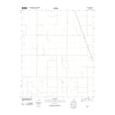
2010 Map of Ogg
USGS Topo · Published 2010About this map
The settlement of Ogg anchors this high plains landscape of Randall County in the early twenty-first century. This portion of the Texas Panhandle is defined by a rigid grid of rural roads and agricultural plots, intersected by the intermittent drainage of Happy Draw and the course of Running Water Rd. The map illustrates the sparsely populated character of the region, where named locations like Black Camp represent key navigational markers in an otherwise wide-open geography. Transportation is centered on a network of Farm-to-Market roads, including Fm 1705 and S FM 1705, which facilitate movement between scattered homesteads and larger regional centers. Named local routes such as Jowell Rd, Lawrence Dr, and Coulter Rd provide a detailed look at the land division and access patterns utilized by local residents during this period.
Find a feature on this map
19 named features on this map. Tap any name to fly to it.
Don’t see what you’re looking for? This feature index may not catch every label — zoom into the map to look around manually.
Map Details
Editions of this 2010 Ogg Map
This is the sole edition of this map. No revisions or reprints were ever made.
Other maps of this area

1954 · Plainview
USGS Topo · 1:250,000

1954 · Clovis
USGS Topo · 1:250,000

1958 · Clovis
USGS Topo · 1:250,000

1958 · Plainview
USGS Topo · 1:250,000

1960 · Canyon
USGS Topo · 1:62,500

1961 · Buffalo Lake
USGS Topo · 1:62,500

1965 · Happy
USGS Topo · 1:24,000

1966 · Tulia NW
USGS Topo · 1:24,000

1966 · Arney
USGS Topo · 1:24,000
1984 · Canyon
USGS Topo · 1:24,000