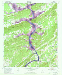
1949 Map of Ohatchee
USGS Topo · Published 1973About this map
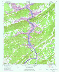
The Coosa River dominates this landscape where Etowah, Calhoun, and St. Clair counties meet. Significant topographical changes are visible through the lens of mid-century hydroelectric development, notably the Neely Henry Lake and H Neely Henry Dam, which reshaped the river's path through the Beaver Creek Mountains. The settlement of Ohatchee serves as a primary hub, while smaller communities and rural landmarks provide valuable points for local research. These include Oldham Chapel, Paint Rock Ch, and Heald Cem, alongside traditional river crossings like Francis Ferry. The presence of the Seaboard Coast Line and a dedicated Landing Strip indicate the area's evolving transportation and economic infrastructure during the post-war era, while the eastern edge is defined by the Fort McClellan Military Reservation.
Find a feature on this map
39 named features on this map. Tap any name to fly to it.
Don’t see what you’re looking for? This feature index may not catch every label — zoom into the map to look around manually.
Map Details
Editions of this 1949 Ohatchee Map
5 editions found
Other maps of this area

1889 · Springville
USGS Topo · 1:125,000

1892 · Springville
USGS Topo · 1:125,000

1900 · Anniston
USGS Topo · 1:125,000

1947 · Cox Gap
USGS Topo · 1:24,000

1947 · Dunaway Mountain
USGS Topo · 1:24,000

1947 · Ragland
USGS Topo · 1:62,500

1947 · Ragland
USGS Topo · 1:24,000

1947 · Glencoe
USGS Topo · 1:24,000

1947 · Wellington
USGS Topo · 1:24,000

1947 · Francis Mill
USGS Topo · 1:24,000