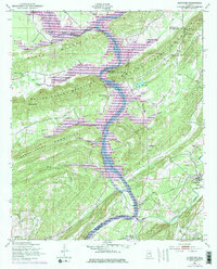
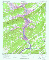
1949 Map of Ohatchee
USGS Topo · Published 1977About this map
The Coosa River anchors this 1949 survey, revealing a landscape defined by the convergence of the Seaboard Coast Line railroad and the river's winding course. The map documents the area just as hydroelectric developments were transforming the waterway, showing the H Neely Henry Dam and the resulting H Neely Henry Lake. Near the settlement of Ohatchee, the terrain transitions from the valley floors of Shoal Creek Valley and Beaver Creek Valley into the steep ridges of Hines Mountain and the Beaver Creek Mountains.
Find a feature on this map
41 named features on this map. Tap any name to fly to it.
Don’t see what you’re looking for? This feature index may not catch every label — zoom into the map to look around manually.
Map Details
Editions of this 1949 Ohatchee Map
5 editions found
Other maps of this area

1889 · Springville
USGS Topo · 1:125,000

1892 · Springville
USGS Topo · 1:125,000

1900 · Anniston
USGS Topo · 1:125,000

1947 · Cox Gap
USGS Topo · 1:24,000

1947 · Dunaway Mountain
USGS Topo · 1:24,000

1947 · Ragland
USGS Topo · 1:62,500

1947 · Ragland
USGS Topo · 1:24,000

1947 · Glencoe
USGS Topo · 1:24,000

1947 · Wellington
USGS Topo · 1:24,000

1947 · Francis Mill
USGS Topo · 1:24,000