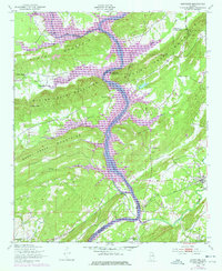
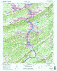
1949 Map of Ohatchee
USGS Topo · Published 1977About this map
The Coosa River anchors this mid-century survey of the Alabama Piedmont, marking the convergence of Etowah, St. Clair, and Calhoun counties. The 1972 revisions highlighted in purple document the significant hydrological changes brought by the construction of the H Neely Henry Dam, which transformed the river into Logan Martin Lake. Before these waters rose, the landscape was defined by the ridges of the Beaver Creek Mountains and the Shoal Creek Mountains, which hemmed in rural settlements like Ohatchee and Ottery.
Find a feature on this map
44 named features on this map. Tap any name to fly to it.
Don’t see what you’re looking for? This feature index may not catch every label — zoom into the map to look around manually.
Map Details
Editions of this 1949 Ohatchee Map
5 editions found
Other maps of this area

1889 · Springville
USGS Topo · 1:125,000

1892 · Springville
USGS Topo · 1:125,000

1900 · Anniston
USGS Topo · 1:125,000

1947 · Cox Gap
USGS Topo · 1:24,000

1947 · Dunaway Mountain
USGS Topo · 1:24,000

1947 · Ragland
USGS Topo · 1:62,500

1947 · Ragland
USGS Topo · 1:24,000

1947 · Glencoe
USGS Topo · 1:24,000

1947 · Wellington
USGS Topo · 1:24,000

1947 · Francis Mill
USGS Topo · 1:24,000