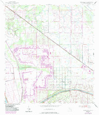
1953 Map of Okeechobee 4 SE
USGS Topo · Published 1983About this map
The St Lucie Canal dominates the southern landscape of this Martin County interior, serving as a critical artery for regional water management with its documented project depth of 8 feet. The surrounding terrain, part of the Allapattah Flats, is defined by a complex network of drainage and citrus-industrial development. Significant infrastructure like the Seaboard railroad cuts diagonally through the territory, linking the settlement of Zana in the northwest to the developing areas near Bessemer in the south. The map documents the specific engineering of the era, from the protective levee systems and spoil banks along the canal to the scattered flowing wells that suggest the hydrological state of the land prior to extensive modern pumping. Pockets of natural landscape like Barber Swamp persist among industrial features like a Sand Pit and a regional substation, illustrating the mid-century transformation of the Florida wetlands into a managed agricultural and industrial corridor.
Find a feature on this map
13 named features on this map. Tap any name to fly to it.
Don’t see what you’re looking for? This feature index may not catch every label — zoom into the map to look around manually.
Map Details
Editions of this 1953 Okeechobee 4 SE Map
5 editions found
Other maps of this area

1953 · Okeechobee 4 SW
USGS Topo · 1:24,000

1953 · Okeechobee 4 SE
USGS Topo · 1:24,000

1953 · Okeechobee 4 NE
USGS Topo · 1:24,000

1953 · Okeechobee 4 NW
USGS Topo · 1:24,000

1953 · Indian Town NW
USGS Topo · 1:24,000

1953 · Indian Town
USGS Topo · 1:24,000

1956 · West Palm Beach
USGS Topo · 1:250,000

1956 · Fort Pierce
USGS Topo · 1:250,000

1957 · West Palm Beach
USGS Topo · 1:250,000

1958 · Fort Pierce
USGS Topo · 1:250,000