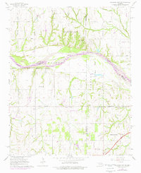
1965 Map of Oklahoma City SW
USGS Topo · Published 1976About this map
The Canadian River serves as a massive natural corridor and county boundary on this mid-1960s survey, separating the growing outskirts of Oklahoma City from the agricultural and industrial lands to the south. The map documents a period of significant infrastructure expansion, evidenced by the Oklahoma City Corporate Boundary reaching deep into the river valley and the presence of the H E Bailey Toll Road cutting across the southeastern corner.
Find a feature on this map
36 named features on this map. Tap any name to fly to it.
Don’t see what you’re looking for? This feature index may not catch every label — zoom into the map to look around manually.
Map Details
Editions of this 1965 Oklahoma City SW Map
3 editions found
Other maps of this area

1893 · Oklahoma City
USGS Topo · 1:62,500

1893 · Minco
USGS Topo · 1:62,500

1904 · Chickasha
USGS Topo · 1:125,000

1954 · Oklahoma City
USGS Topo · 1:250,000

1956 · Oklahoma City
USGS Topo · 1:24,000

1956 · Oklahoma City
USGS Topo · 1:62,500

1956 · Oklahoma City SE
USGS Topo · 1:24,000

1957 · Oklahoma City
USGS Topo · 1:250,000

1963 · Oklahoma City
USGS Topo · 1:250,000
1965 · Newcastle
USGS Topo · 1:24,000