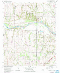
1965 Map of Oklahoma City SW
USGS Topo · Published 1983About this map
The Canadian River serves as a winding natural boundary through this mid-1960s survey, separating the southern reaches of Oklahoma City from the agricultural and industrial lands of Grady and McClain Counties. The landscape is defined by the intersection of rural life and early suburban expansion, with the northern section featuring the Pentecostal Campground and Camp Kickapoo near the river bluffs. To the south, the community of Tuttle and the emerging hub of Newcastle anchor the terrain, connected by a network of sectional roads and the modern path of the H E Bailey Turnpike.
Find a feature on this map
29 named features on this map. Tap any name to fly to it.
Don’t see what you’re looking for? This feature index may not catch every label — zoom into the map to look around manually.
Map Details
Editions of this 1965 Oklahoma City SW Map
3 editions found
Other maps of this area

1893 · Oklahoma City
USGS Topo · 1:62,500

1893 · Minco
USGS Topo · 1:62,500

1904 · Chickasha
USGS Topo · 1:125,000

1954 · Oklahoma City
USGS Topo · 1:250,000

1956 · Oklahoma City
USGS Topo · 1:24,000

1956 · Oklahoma City
USGS Topo · 1:62,500

1956 · Oklahoma City SE
USGS Topo · 1:24,000

1957 · Oklahoma City
USGS Topo · 1:250,000

1963 · Oklahoma City
USGS Topo · 1:250,000
1965 · Newcastle
USGS Topo · 1:24,000