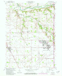
1963 Map of Onward
USGS Topo · Published 1980About this map
The Wabash River forms the northern boundary of this central Indiana landscape, where the agricultural plains of Tipton and Jackson townships meet the industrial expansion of the mid-20th century. The southern portion of the map is dominated by the sprawling infrastructure of Grissom Air Force Base, showing clear development of runways and base facilities alongside older rural landmarks. Settlement patterns follow the drainage of Pipe Creek and its tributaries, with the village of Walton serving as a local hub near the Conrail line. Genealogists will find a wealth of family history preserved in numerous burial grounds, such as Bowyer Cem, Metzger Cem, and Little Deer Creek Cem. The transition from small-scale farming to large military operations is evident, with Randall Sch and Randall Cem standing as anchors of a changing community landscape.
Find a feature on this map
34 named features on this map. Tap any name to fly to it.
Don’t see what you’re looking for? This feature index may not catch every label — zoom into the map to look around manually.
Map Details
Editions of this 1963 Onward Map
3 editions found
Other maps of this area

1951 · Peru
USGS Topo · 1:24,000

1951 · Onward
USGS Topo · 1:24,000

1951 · Twelve Mile
USGS Topo · 1:24,000

1951 · Bunker Hill
USGS Topo · 1:24,000

1953 · Danville
USGS Topo · 1:250,000

1955 · Danville
USGS Topo · 1:250,000

1955 · Logansport
USGS Topo · 1:24,000

1955 · Anoka
USGS Topo · 1:24,000

1956 · Danville
USGS Topo · 1:250,000

1959 · Galveston
USGS Topo · 1:24,000