
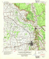
1939 Map of Opelousas
USGS Topo · Published 1942About this map
Opelousas serves as the central hub of this 1939 survey, showcasing a dense network of bayous and railroads that defined St. Landry Parish before mid-century modernization. The landscape is dominated by the complex hydrology of Bayou Teche, Bayou Boeuf, and Bayou Cocodrie, which carve through the region's agricultural and industrial centers. Significant local landmarks include the Wartell Plantation and the Ville Platte Oil Field, illustrating the transition from traditional plantation economies to the burgeoning petroleum industry.
Find a feature on this map
70 named features on this map. Tap any name to fly to it.
Don’t see what you’re looking for? This feature index may not catch every label — zoom into the map to look around manually.
Map Details
Editions of this 1939 Opelousas Map
2 editions found
Other maps of this area

1935 · Turkey Creek
USGS Topo · 1:62,500

1940 · Arnaudville
USGS Topo · 1:62,500

1947 · Ville Platte
USGS Topo · 1:31,680

1947 · Chataignier
USGS Topo · 1:31,680

1947 · Pitreville
USGS Topo · 1:31,680

1948 · Bunkie
USGS Topo · 1:62,500

1949 · Turkey Creek
USGS Topo · 1:62,500

1952 · Lake Charles
USGS Topo · 1:250,000

1954 · Lake Charles
USGS Topo · 1:250,000

1954 · Baton Rouge
USGS Topo · 1:250,000