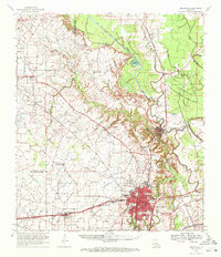
1970 Map of Opelousas
USGS Topo · Published 1972About this map
Opelousas serves as the focal point of this South Louisiana landscape, where the confluence of three major rail lines—the Southern Pacific, Texas and Pacific, and Missouri Pacific—illustrates the city's historic role as a transportation hub. The surrounding St. Landry Parish countryside is a dense network of watercourses, including Bayou Teche and Bayou Courtableau, which supported early settlement patterns visible through numerous community landmarks like Grand Prairie Ch & Cem and Sacred Heart Chapel & Cem.
Find a feature on this map
74 named features on this map. Tap any name to fly to it.
Don’t see what you’re looking for? This feature index may not catch every label — zoom into the map to look around manually.
Map Details
Editions of this 1970 Opelousas Map
2 editions found
Other maps of this area

1935 · Turkey Creek
USGS Topo · 1:62,500

1939 · Opelousas
USGS Topo · 1:62,500

1940 · Arnaudville
USGS Topo · 1:62,500

1947 · Ville Platte
USGS Topo · 1:31,680

1947 · Chataignier
USGS Topo · 1:31,680

1947 · Pitreville
USGS Topo · 1:31,680

1948 · Bunkie
USGS Topo · 1:62,500

1949 · Turkey Creek
USGS Topo · 1:62,500

1952 · Lake Charles
USGS Topo · 1:250,000

1954 · Lake Charles
USGS Topo · 1:250,000