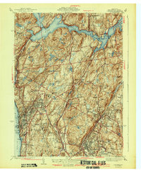
1943 Map of Ossining
USGS Topo · Published 1943About this map
Sing Sing Prison stands prominently along the Hudson River shoreline in this mid-century view of Westchester County. The landscape is defined by the massive New Croton Reservoir and its associated Croton Dam, which dominate the northern half of the region. This era of development shows a significant concentration of religious and educational institutions, including the Maryknoll Seminary, Maryknoll Convent, and Briarcliff Junior College. Local transportation relies on the New York Central railroad and historical corridors like the Albany Post Road. The interior is dotted with private estates and recreational grounds such as the Sleepy Hollow Country Club and Briarcliff Country Club, interspersed with small crossroads like Millwood and Chappaqua. The topography reveals a transition from the riverfront heights of Ossining to the interior hills and numerous small glacial ponds and lakes.
Find a feature on this map
88 named features on this map. Tap any name to fly to it.
Don’t see what you’re looking for? This feature index may not catch every label — zoom into the map to look around manually.
Map Details
Editions of this 1943 Ossining Map
4 editions found
Other maps of this area

1892 · Stamford
USGS Topo · 1:62,500

1892 · West Point
USGS Topo · 1:62,500

1892 · Carmel
USGS Topo · 1:62,500

1892 · Tarrytown
USGS Topo · 1:62,500

1893 · Carmel
USGS Topo · 1:62,500

1893 · Stamford
USGS Topo · 1:62,500

1893 · Tarrytown
USGS Topo · 1:62,500

1894 · West Point
USGS Topo · 1:62,500

1894 · Carmel
USGS Topo · 1:62,500

1899 · Stamford
USGS Topo · 1:62,500